
Walk with us May 29, 30 & 31, 2026
Walk any portion of the walk, whether it's 1 km or more! Pick a starting point on the map and follow the route to your stopping point. Or join one of our groups that are walking together this year. See Family-Friendly routes at the bottom or the page. Or join us by choosing to do a solidarity walk in your community - just register and let us know where you are walking.


Route 1
Fort Langley National History Site to The Dyke
Begin at Fort Langley National History Site, and follow River Rd. which turns into 88 Avenue all the way until you reach The Dyke.

Route 2
The Dyke (88th and Trans Canada Trail) to McTavish Road ~ 7km
Head west on 88 Ave toward the Trans Canada Trail, once you have reached the Trans Canada Trail turn left to begin the trail, after 4km you will turn right onto Lefeuvre Rd, and after 2.3km turn left on McTavish Road. Be cautious especially on Lefeuvre Rd. Visibility is limited on this road and there is no sidewalk.

Route 3
McTavish Road to Mount Lehman United Church ~ 5.6 km
Head east on McTavish Road toward Bradner Rd, Turn right onto Satchell St. (Trans Canada Trail) follow the trail until you reach Mount Lehman Rd, then turn right onto Mount Lehman Road and walk until you reach the Mount Lehman United Church. Be cautious with this route. There are areas where the road is narrow.

Route 4
Mount Lehman United Church to Trans Canada Trail Parking Lot ~ 5km
Head south on Mount Lehman Rd, turn left onto Burgess Ave and follow the path, turn right onto Olund Rd, turn left to begin the Trans Canada Trail follow it for 2.9 km, and then take a slight right to continue on the Trail and the final destination will be on your left.
Please note: The Eastern end of this section, close to the river has had flooding on occasion in years past. We will be monitoring it and letting people know if it is not passable.

Route 5
Trans Canada Trail Parking Lot (go under the Mission Bridge) to Riverside Road ~ 8km
Head southeast on the Trans Canada Trail for 300m, then take a slight left to stay on the Trail and follow the trail under the Mission Bridge until you reach Riverside Rd.
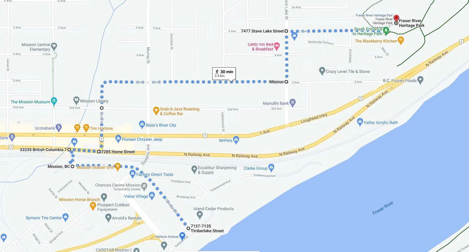
Route 6
Timberlake Street, Mission to Fraser River Heritage Park
Head northwest on Timberlake St toward Broadway Ave. Continue onto Railway Ave S through the Mission Train Station Parking Lot and take the pedestrian overpass Turn left onto Horne Street and continue to follow Horne St onto 3 Ave. Turn left onto Stave Lake St and turn right onto 5 Ave. Destination will be on the left - Fraser River Heritage Park.

Route 7
Fraser River Heritage Park to the site of St. Mary’s Residential School (currently Pekw'Xe:yles Reserve)
This route follows a gravel path.
Family-Friendly Routes

Fort Langley
Park at the Fort Langley National Historic Site. Walk towards Church Street and head north towards the river. You will connect with the trail and start walking west along the Fort to Fort Trail. Walk as far as you're comfortable and then turn back.

Langley Arboretum
Park at the Arboretum. Begin the trail going east or west on the loop around the gardens. To take the longer route towards the Langley airport you will see a trailhead at the north end of the loop. Take this trail north towards 56th Avenue. Continue along until you reach 216th Street then turn around and walk back to the Arboretum. This trail is completely off any roads and has a fence between it and 56 Avenue for that stretch.

Abbotsford - Mill Lake
Try this 2.3-km loop trail in Abbotsford, British Columbia. Generally considered an easy route, it takes an average of 30 min to complete. This is a popular trail for birding, trail running, and walking, but you can still enjoy some solitude during quieter times of day.

Chilliwack - Vedder River Trail
The Vedder River Rotary Trail is a beautiful trail that follows the Vedder River for about 8km offering many scenic views. The trail is a popular walking, jogging, or cycling route and busy on the weekends with families and others out walking their dogs.
There are several parking lots located throughout the route and you can choose to do a shorter version of the trail. The route described below begins at Vedder Park and goes the entire route, ending at the North Dyke Trail.
Engaging Resources
If you can't walk, or once you finish walking, please join us by reading/watching the Indigenous information, stories and videos which can be found on HERE.
Join the Facebook event and post photos letting us know you completed your selected route or a section of the Walk. Post your starting point of your walk and at your stopping point, and any other fun photos along your walk to the Facebook event page!